VITAL STATISTICS
VITAL STATISTICS
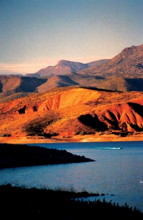
 The Great Tonto Basin, a verdant oasis in the sprawling Sonoran desert, lies in the Salt River valley beneath the Mogollon Rim (Muggy-own) in Central Arizona,
roughly mid-way between Phoenix and Payson. Bounded by Mt. Ord and Four Peaks to the west, the Hellsgate Wilderness Area to the north,
and the Sierra Ancha and Aztec Peak to the east, the broad, grassy plain contains Roosevelt Lake, a favorite of avid anglers searching for
trophy largemouth and smallmouth bass, channel catfish and crappie (pronounced croppie), and home to several professional tournaments. Add in water-skiing,
jet-skiing, sailing, swimming and general boating recreation and you have one of the most popular water recreation destinations in the region.
At an elevation of 2151' ASL, air temperatures generally fall 5º to 10º cooler than Phoenix in the summer, and 20º to 30º warmer than Payson in the winter. Although water temperatures can exceed 90ºF in July, cooling afternoon thunderstorms are a blessing. With miles and miles of beach area for camping along the lake's edges, it is the largest man-made reservoir located entirely within the state of Arizona.
Originally settled by cattle ranchers in the mid-1800s, the Great Tonto Basin is now home to approximately 1500 full-time residents. And although this major center for hunting, fishing, boating, camping, quad-riding and general vacationing is geographically close to Phoenix, the shortest route from the south is through Apache Junction via the unpaved Apache Trail, so the number of visitors on any given day is surprisingly less than many of the other lakes close to the city. This makes Roosevelt Lake a delightfully uncrowded weekend destination, and a place of virtual serenity mid-week.
Paved access from the west and north is via the Beeline Highway (SR 87) to SR 188, which then follows the western shoreline of the lake south
to Globe. Along the highway you'll find the communities of Jake's Corner, Punkin Center, Tonto Basin and Roosevelt, offering two grocery stores,
a post office, several home-style restaurants, two establishments providing motel-style accommodations, four gas stations, four nightspots
and a private marina on the lake with gas services, a general store open to the public, and a soon-to-be-completed, cliff-side restaurant with panoramic lake views. In
addition to ample "at large" locations for RVers and tent campers, there is a wildlife refuge area at the northern end of the lake, and
Popular destinations for tourists, hikers and photographers are the guided and self-guided tours at the Tonto National Monument, just a couple miles south of the marina on Hwy 188. These well-preserved cliff dwellings, built high above the basin floor and occupied by the Salado culture between 1150 and 1450 AD, have been both protected and open to the public since 1907, when President Theodore Roosevelt established the monument under the Antiquities Act of 1906. Immediately adjacent to the marina, Tonto National Forest Visitor Center features a museum with archeological exhibits and a 12-minute orientation slide program, a gift shop, interpretive literature, restrooms and vending machines.

|